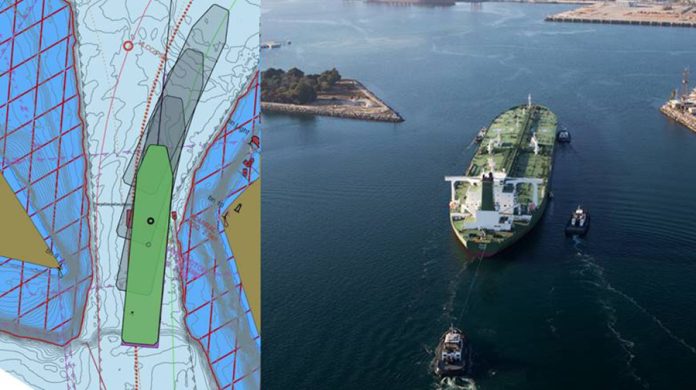
Port pilots across the United States will now have a new high-precision navigation tool thanks to the Port of Long Beach, Jacobsen Pilot Service, and the National Oceanic and Atmospheric Administration (NOAA), making shepherding ships through the underwater terrain unique to each port safer than ever.
“The Port of Long Beach handles cargo valued at more than US$200 billion every year, and safety is our No. 1 priority in everything we do,” stated Long Beach Harbor Commission President Bobby Olvera Jr.
“Our highly skilled in-house survey team makes Long Beach the ideal port to develop this new resource. Most ports do not have their survey teams, let alone one with the talent, expertise and cutting-edge equipment we invest in so we can regularly inspect and maintain the 4,600 acres of water that surrounds our world-class gateway,” said Mario Cordero, CEO of the Californian port.
S-102 is a set of data files developed under NOAA’s Precision Marine Navigation Program that provide high-resolution depth data that can be added to NOAA’s standard Electronic Navigational Chart (ENC). While standard charts show the shoreline, breakwater, buoys, and land area, S-102 files allow users to create detailed custom depth contours in their navigation systems and depict the seafloor in greater detail.
Furthermore, having worked closely with NOAA on numerous initiatives for more than 30 years, Jacobsen Pilot Service was the obvious choice to collaborate with the federal agency to demonstrate the new tool. It was also chosen because its technology, which includes software that measures water levels, tides, currents, waves, and weather, is regularly upgraded.
This data may be combined with digital charts to provide port pilots, who are already so skilled that they can sketch the outlines of San Pedro Bay from memory, with enhanced situational awareness of dynamic situations in real time.
“There is no room for error,” pointed out Thomas Jacobsen, President of Jacobsen Pilot Service.
He further added, “We’re moving the largest ships in the world, and we need all the precision we can get. We’re talking about fully loaded supertankers that are 1,100 feet long, 200 feet wide and comparable in depth to a seven-story building.”
“These ships have a draft of 69 feet in a channel that is 76 feet deep,” stated Jacobsen. “We’re already close to the bottom and 1 degree of pitch can increase the ship’s draft by 10 feet! We have to use positive tides, the highly accurate S-102 charts, along with sophisticated ship dynamic modelling programs that predict the ship’s motion in the given sea state, so we can safely navigate these ships into port,” noted Jacobsen.
The S-102 files are the result of over a decade of collaboration. According to Jacobsen, the Port’s Survey Division was critical to the growth of the digital resource. “They understand the language of bathymetry and hydrography and quickly deliver the most current data to NOAA.”


